Wednesday, January 11, 2017

Sense and Avoid Technology: The SF40/C


Sense and avoid technology is perhaps one of the most sought out technologies in the field of aviation. The introduction of unmanned aerial systems threatens to make air navigation a highly complex activity. Multiple companies are currently working around the clock to develop an effective sense and avoid system. Among these companies is LightWare optoelectronics which has successfully introduced a promising product; the SF40/C. LightWare Optoelectronics is a South African company founded in 2011 with the objective of raising awareness about the design, development and application of laser rangefinders. With over 40 years of experience in the design and development of laser range finders, LightWare Optoelectronics aims at advancing this technology for the benefit of humanity.

LightWare Optoelectronics has developed a new sense and avoid product dubbed the SF40/C. The SF40 is a light detection and ranging (LiDAR) sensor capable of sensing and detecting obstacles and determining an alternate route. The SF40 can detect and measure obstacles up to 100 meters away. In addition, its on-board analysis and navigation tool systematically finds escape routes. The SF40 offers up to 4.5 complete data refreshes per second. This sensor is easy to configure and use even with a low performance processor. The SF40 performs simultaneous data collection and analysis for quick response to obstacles and continuously monitors internal systems status warning the operator of any system faults. The SF40 can be easily connected to standard flight controllers through a serial port.


The sensor uses a scanning rangefinder laser with a range of 100 meters. The SF40 sits on a 360 degree spinning disk giving it the ability to sense obstacles all around it. The system’s rotation can be adjusted to 1 , 2.25, or 4.5 revolutions per second. Critical functions of the sensor are managed by an integrated circuit known as a Field-Programmable Gate Array (FPGA). The FPGA allows the system to be programmed on the field after manufacture allowing the 32-bit arm cortex-M3 processor to monitor systems performance and reliability as well to conduct data analysis. The analysis of data is conducted asynchronously allowing the system to expedite through multiple calculations. An analytical tool kit then uses this data to produce alternatives and execute navigation decisions.

Some of the tools used by the system are fully autonomous, and some other require it to answer navigational questions such as “which way should I go?” or “is it safe to change direction?”. The main navigation tools are: alarm zones which scanned predetermined areas and and warns the operator of any obstacle; a virtual laser rangefinder (VLRF) which measures the distance to an obstacle in any direction; a searchlight checks that a specific area is cleared of obstacles before a change in direction is executed; a navigator finds open pathways between obstacles; and a mapper provides all of the measurements in a specified area.

The SF40 hardware is composed of the SF40 sensor, the power connector, the user connector, LED indicators, the motor, the laser, and the opto and servo. The SF40 has two modes of serial port communication; MMI communications and HMI communications. The SF40 weighs 270 grams not including cables which limits its ability to be integrated on the smaller unmanned aerial systems. Resolution is selectable from 0.03 to 0.12 meters. The sensor measures 91 millimeters in height and 79 millimeters in its largest diameter. The SF40 is commercially available and cost $999 excluding taxes, and shipping. SF40’s ability to quickly scan distances up to 100 meters providing 360 degree obstacle sensing make it specially useful in unmanned aerial systems.


References
Lightware Optoelectronics. (n.d.). SF40/C (100 m). Retrieved from http://www.lightware.co.za/shop/en/scanning-and-obstacle-detection/45-sf40c-100-m.html

Wednesday, January 4, 2017

Controlling your Drone


In order to enhance and optimize the use of unmanned systems it is important to utilize a  reliable ground control system. A system that sports a variety of useful features for the control of  unmanned aerial systems is the INEXA Ground Control System (GCS). The Inexa GCS is an advanced ground control station that allows unmanned aircraft operators to control multiple unmanned aircraft while  complying with Federal Aviation Regulations (FAA). Through multiple tests the system has demonstrated to be a safe, reliable, and secure tool in the control of unmanned aerial systems.


Among its many features, INEXA has an intuitive design giving the operator the ability to control the system and its payload with a simple drag and drop; the enterprise data integration systems gives operators additional situational awareness tools that include aviation weather services, and other useful third party products. The augmented video overlays the system’s video with real time terrain elevation , geographic information system, and satellite imagery. The advanced built-in camera control system allows the operator to slew the sensors without the use  of manual control. Finally, the open-architecture design was designed to support plug-ins as well  as additional features that allows users to enhance mission capabilities and customization.


Along its amazing features, every INEXA control system include; a mission planning function; an integrated simulation system useful for training and demos; a route editor; a mission execution function; a flight management console; and an alert management system which monitors diagnostics and provides visual and audible alerts if issues arise. The INEXA control system is designed and developed by Insitu. Insitu offers a $60 annual subscription which covers maintenance and software updates. Insitu also offers a $60 Arducopter plug-in.


Insitu is currently developing other features which will be soon be commercially available  to those INEXA users. Among its new features are a search plug-in that will allow operators to plan and execute wide area searches by using recognized search patterns; an RF link analysis plug-in will help operators identify areas where terrain or other obstructions could interfere with the transmission of information or the control of the aircraft. A third and final product currently under development is the airspace management plug-in which will alert operators of potential airspace violations and recognize airspace areas to avoid.


There are other optional advanced features which make INEXA a very versatile product. Its optional advanced features include; multiple vehicle control which allows the system to control multiple platforms from a single INEXA; multi-video control is able to display multiple streaming video feeds, STANAG 4609, a NATO standardization agreement, for STANAG and MISB compliant video; NITF Snapshot that allows operators to create video snapshots in NITF format, and laser range finder support.


The wide range of features of the INEXA control system makes it an ideal tool for the operation of small unmanned aerial systems. INEXA is simple to operate and it does not demand  a long list of requirements.

INEXA control minimum requirements:
Windows 7 Professional or Ultimate (64-bit), Service Pack 1
Processor: Quad Core, 2.2 Ghz, 6MB Cache
Memory: 4 Gb DDR3 1600 Mhz
Graphics Card: 1 Gb GDDR5 Dedicated Memory, DirectX 11.0, Shader 5.0 Gaming Card
Display Resolution: 1280 x 1024 at 96 DPI
Online Map Service: Broadband Internet Connection separate from vehicle specific
communication hardware requirements
Offline Map Service: ESRI ArcMap 10.1

The INEXA control is a great system and its developers seem to be constantly looking for  
ways to improve it.I did not find many drawbacks. The system is able to carry out multiple
functions and it offers a lot of great features. INEXA, however, only supports windows based PC.  
A recommendation for this system is to extend its use to smartphones and tablets or at least
android and IOS devices which are the most popular on the market. INEXA also only supports
Quadcopters; therefore, a second recommendation is to extend its use to drones with more than  
four rotors siven than the small UAS market is continually growing and adding all types of
complex designs.


References


Insitu. (n.d.). INEXA control: Part of the INEXA professional unmanned platform. Retrieved from

https://insitu.com/information-delivery/command-and-control/inexa-control

sUAS news. (2016, November 4). INEXA control subscription. Retrieved from
https://www.suasnews.com/2016/11/inexa-control-subscription/


Sunday, December 11, 2016

Unmanned Systems Integration

Unmanned systems have rapidly gained popularity over the last ten years, and although the Federal Aviation Administration (FAA) has already announced plans to integrate unmanned aerial systems in the national airspace (NAS), progress seems to have slowed down to a crawl. The reason that the integration of unmanned systems is more challenging than originally thought is due to controversial issues, specifically the issue of privacy. In order to ensure a smooth integration and implementation of unmanned systems in within known limits, certain issues will need to be addressed. For the purpose of simplicity this post will discuss the implementation of law enforcement unmanned aerial systems.

A seamless transition would need to address multiple hot topics, specially the privacy, ethical, safety, and lost link or lost of control implications. Due to the amount of negative publicity, it is important to remember that getting people to be receptive to your ideas and points of view can be a lot more difficult than we might think.

The privacy issue is perhaps one of the most widely discussed subjects in regards to the integration of unmanned systems within the community. Because privacy is the most important right that we have as Americans, it is important for each company to specifically address the issue. Enact rules within the company, that illegal violation of privacy would not be tolerated. Law enforcement UAS can initially seem intimidating, but all police departments using drones should guarantee the community that drones will only specifically track areas where criminal activities is highly probable.

The topic of ethics can be directly tied to the issue of privacy. Every police department should include a code of ethics. Police department should continue to enforce the law and remain unbiased and free of prejudice and only prosecute those people who are actively involved in criminal activity. Assumptions should never be made based on race, or ethnic background.

When it comes to safety, law enforcement unmanned aerial systems should do what the law enforcement mission dictates; to ensure the safety of every citizen. Law enforcement unmanned aerial systems should be able to block a portion of working airspace to ensure that they can operate freely and have the flexibility to conduct its mission in a safe manner. Due to the nature of the mission, I believe law enforcement drones should be carefully inspected before and after flights by an expert in the system.

Finally, lost link situations could pose a threat to other people or aircraft. Fortunately, lost link conditions are being addressed  and systems are now equipped with a return home feature in case of lost link. Systems are also equipped with multiple sense and avoid sensors that allow it to maneuver away from obstacles while returning to the launch point.

The integration and implementation of unmanned aerial systems for law enforcement purposes should not create skepticism if a solid plan that offers transparency is developed and shared with the community. Once people begin to see positive results due to the benefits offered by unmanned aerial systems, the community will be more receptive.

Wednesday, December 7, 2016

UAS Sensor Placement


The DJI Phantom 4 Pro is a small aerial imaging unmanned aerial system (UAS). The Phantom 4 Pro features a one-inch sensor with an F2.8 aperture, capable of 4K, 60 frames per second video recording as well as 14 frames per second burst mode, 20 megapixel photography. Its mechanical shutter eliminates the rolling shutter bending typically seen when taking photographs at high speeds. The system is accompanied by a Ground Control Station (GCS) controller with its bright, 1080p, 5.5 Inch monitor. During video recording, Phantom 4 Pro offers active tracking with three intelligent flight modes; profile, which tracks the target horizontally from any perspective; spotlight, locks the camera on a specific subject and follows it from any angle; and circle, which records video 360 degrees around a subject (DJI, 2016; Perlman, 2016).


Another interesting feature of the Phantom 4 Pro is Tap fly and, the newly added, reverse tap fly. Tap fly allows the operator to tap a point on the map screen and the UAS will fly to that point, reverse tap fly, on the other hand, allows the operator to keep the camera focus on a subject while it flies to a specific point. The Phantom 4 has been equipped with obstacle avoidance capability; Forward, rear, downward, and infrared side sensors provide five direction obstacle sensing. In the event of a lost link condition, the Phantom 4 Pro is able to return home avoiding any obstacles and it even flies the same route home while trying to regain link. Flight endurance on the Phantom 4 Pro has been extended to 30 minutes. The phantom 4 Pro is made of titanium alloy and magnesium alloy which decreases weight and increases durability (DJI, 2016; Pearlman, 2016).


Finally, the GCS controller of the Phantom 4 Pro integrates a two frequency transmission support at 2.4 GHz a d 5.8 GHz which reduces the probability of interference. When the systems is switched on the system automatically analyzes both frequencies and selects the one with the least amount of interference to ensure smooth signal and video transmission. With an ascent speed of 6 meters per second and a descent speed of 4 meters per second, the Phantom 4 Pro can reach speeds of up to 45 mph. Additionally, the system has a maximum service ceiling of 6,000 meters and utilizes GPS and GLONASS for positioning (DJI, 2016).


Race drones are a lot smaller and lighter and are designed to reach speeds of over 100 mph. These systems are typically custom made and specifically designed for speed, agility, and endurance (Bloomberg, 2016). One of the fastest race drones in the market is the Arris FPV 250. The Arris FPV 250 is a small sport UAS made up of composite carbon/glass fiber. The Arris carries a 700TVL sensor that provides excellent quality video and has no video latency making it ideal for racing. The total weight of the system, with the battery, is 554 grams and it has total flight endurance of 10 minutes. One of the most interesting features of race drones includeing the Arris is that these systems are fully customizable. Beginners; however, are recommended to use the system as it comes before deciding to customize (Berstein, 2016; ArrisHobby, n.d.).

The Arris FPV 250 is designed as a first person view (FPV), meaning that the operator will see exactly from the system’s perspective. These systems are most commonly compatible with FPV goggles for a more exhilarating experience. Racing drones’ sensors are fixed in the front of the UAS which makes them ideal for racing. Imaging unmanned aerial systems, on the other hand, are designed to record video and take photos. The Phantom 4 Pro’s sensor has a horizontal field of view of 70 degrees and a vertical field of view of +/- 54 degrees and it is specifically designed to record high quality imaging. In the case of the Phantom 4 Pro, sensors are distributed throughout the system to provide more effective obstacle avoidance.


References

ArrisHobby FPV racing drones store. (n.d.). Retrieved from
http://www.arrishobby.com/arris-fpv250-mini-racing-sport-quadcopter-bnf-assembled-p-2616

Bersnstein, B. (2016, March 18). Drone racing: 5 fastest drones to buy. Retrieved from
http://heavy.com/tech/2016/03/best-drone-racing-fastest-racing-drones-to-buy-fpv-racer-quadco pter/

Bloomberg. (2016, 23 March). Go inside the world’s first $1 million drone race. [video file] retrieved fromhttps://www.youtube.com/watch?v=pZ0viMxYDA4

DJI. (2016, November 15). DJI: Introducing Phantom 4 Pro. [video file]. Retrieved from https://www.youtube.com/watch?v=ZVNO-fib6fg

Perlman, A. (2016, June 24). The top professional drones for serious commercial UAV pilots. Retrieved from http://uavcoach.com/professional-drones/

Thursday, December 1, 2016

Using Unmanned Maritime Systems in Search and Rescue


For this assignment I have selected the submarine rescue diving and recompression system (SRDRS). The SRDRS is an unmanned underwater system used to rescue damaged or disabled submerged submarines. It is designed as a rapid deployment system in the event of a submarine accident and can be easily transported by air, ground, or sea. Once on site, the SRDRS is tethered to a mothered ship, lowered into the water and remotely operated to the accident area where it attaches to the disabled submarine’s hatch. The SRDRS is able to carry up to 16 rescued personnel. The system is comprised of three subsystems; the assessment/underwater work system (AUWS); the submarine rescue system-rescue capable system (SRS-RCS); and the submarine rescue system-submarine decompression system (SRS-SDS). The SRDRS is built by Phoenix international in San Diego, California, it measures 49 feet in length and can reach a maximum depth of 2,000 feet (Keller, 2015; U.S. NAVY, 2015).


The first system of the SRDRS, the AUWS, consists of the ADS2000, is a manned atmospheric dive system capable of clearing debris and inspecting the damaged submarine. This system is expected to be replaced soon by an unmanned underwater system. The second system consists of the pressurized rescued module (PRM), launch and recovery system, and support equipment. The third system, the submarine decompression system (SDS), is the system that allows rescued personnel to remain under pressure providing direct transfer to decompression chambers (submarine rescue, n.d.; U.S. NAVY 2008).


What proprioceptive and exteroceptive sensors does your selected system have that are specifically designed for the maritime environment?

Among the proprioceptive and exteroceptive sensors on the SRDRS are forward and aft scanning sonar, doppler sonar, forward profiling sonar, ultra-short baseline (USBL) acoustic tracking beacon, charge-coupled device (CCD) image sensor, and a SIT equivalent ocean camera. A total of 12 cameras and three scanning sonars.

What is one modification you would make to the existing system to make it more successful in maritime search and rescue operations?

The only modification I would make, which by the way is one of the already proposed changes, is to make the assessment/underwater diving system fully unmanned. Unmanned underwater vehicles can now be used to conduct inspections of the submerged, disabled vehicles.

How can maritime unmanned systems be used in conjunction with UAS to enhance their effectiveness?

Maritime unmanned systems can work in conjunction with unmanned aerial systems and enhanced operational effectiveness by maintaining communication between the two or three assets. UAVs can get to the area rapidly and analyze the situation before the unmanned maritime system gets on station. In fact, earlier this year a Lockheed Martin’s unmanned underwater vehicle, the Marlin 2, was able to launch a Vector Hawk unmanned aerial vehicle proving that unmanned underwater systems and unmanned aerial vehicles can work jointly and autonomously toward the same objective (Lockheed Martin, 2016).

What advantages do unmanned maritime systems have over their manned counterparts? Are there sensor suites that are more effective on unmanned systems?

One the advantages that unmanned maritime systems have over their manned counterparts, is cost savings. Because unmanned maritime systems do not carry humans on board, they don’t need life support systems allowing them to be smaller in size.

References

English, J. & Gibson, J. (n.d.). Pressurized rescue module system: U.S. NAVY’s future submarine rescue vehicle. Retrieved from http://www.oceanworks.com/admin/sitefile/1/files/OW2002_Pressurized%20Rescue%20Module.pdf

Keller, J. (2015, November 9). Navy readies deployable unmanned underwater vehicle to rescue sunken submaribne crews. Retrieved from http://www.militaryaerospace.com/articles/2015/11/unmanned-submarine-rescue.html

Lockheed martin. (2016, September 28). From under the sea to up in the air: Lockheed Martin conducts first underwater unmanned aircraft launch from unmanned underwater vehicle. Retrieved from http://www.lockheedmartin.com/us/news/press-releases/2016/september/160928-rms-first-underwater-unmanned-aircraft-launch-from-unmanned-underwater-vehicle.html

Submarine rescue diving and recompression system. (n.d.). Retrieved from http://www.globalsecurity.org/military/systems/ship/systems/srdrs.htm

U.S. NAVY. (2015, October 19). Submarine rescue diving and recompression system (SRDRS). Retrieved from http://www.navy.mil/navydata/fact_display.asp?cid=4100&tid=400&ct=4

U.S. NAVY. (2008, October 2). New submarine rescue asset joins fleet. Retrieved from http://www.navy.mil/submit/display.asp?story_id=40147

Robotic Sensing in Disaster Response

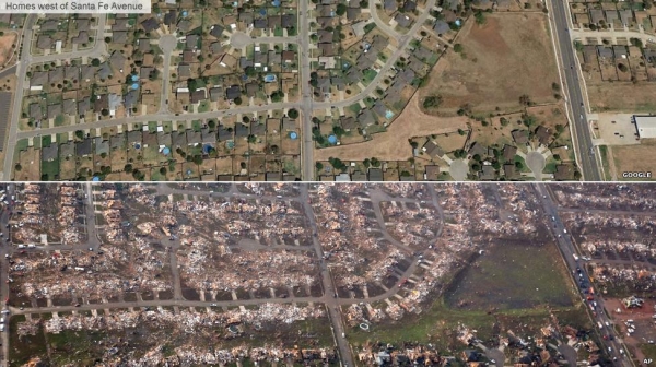
In the article tiled "Drones: The future of disaster response" Heather Kelly begins the article by highlighting the difficulties faced by first responders as they arrive to the devastating scene left by a massive tornado that hit Moore, Oklahoma on May 20, 2013. Destroyed homes, downed power lines, and massive amounts of debris blocked roads in and out of the area making it nearly impossible to navigate the area in search for survivors. Although the air provided easier access to the area, the airspace was quickly inundated by the loud noise of media and law enforcement helicopters making it more difficult to hear those survivors trapped under the debris. The entire area was consequently declared a no-fly zone and the search for survivors continued on the ground.

Image result for moore oklahoma tornado

Nevertheless, advancements in airborne technology will improve disaster response. One emerging technology that can prove vital to disaster response efforts is the use of unmanned aerial vehicles (UAVs). Unmanned aerial vehicles can be light weight, portable, quiet, and versatile; qualities that can prove invaluable to search an rescue missions. UAVs provide the flexibility to be launched quickly from any location and the data gathered can be transmitted real time to first responders on the ground. There is a lot of excitement about the inclusion of UAVs in search and rescue, but regulatory issues, privacy concerns, and media portrayal continue to halt progress. 

One sensor that can provide invaluable assistance to search and rescue efforts is the infra-red sensor or IR sensor. An IR sensor is a special sensor that can detect the light in the IR region of the electromagnetic spectrum. IR energy is not visible to the human eye making it beneficial for night operations. IR sensors are also sensitivy to heat which makes them ideal in identifying a human heat signature. Mrs. Kelly discusses how a Canadian UAV with an IR sensor was able to search and track a man whose car had rolled off the road into the forest. The incident is living proof of the potential benefits of unmanned systems, but privacy issues remain a controversial topic. The article goes on to discuss how privacy concerns are mounting in regards to unmanned systems, and how potential applications for unmanned systems continue to attract more enthusiasts. Mrs. Kelly's article seems to advocate for the use of unmanned systems and does a great job presenting examples that support her position.

Image result for unmanned systems disasters

References

Chilton, A. (2014, October 15). The working principle and key applications of infra-red sensors. Retrieved from http://www.azosensors.com/article.aspx?ArticleID=339

Kelly, H. (2013, May 23). Drones: The future of disaster response. CNN. Retrieved from http://www.cnn.com/2013/05/23/tech/drones-the-future-of-disaster-response/